Following an initial approach to the team (and other MRTs and SARDA) at the September 2008 Mountain Rescue Conference, in early October 2008 the team received a Satmap Active 10 GPS unit and associated accessories valued at nearly £500.00 from Satmap Systems Limited for a free trial and evaluation period by the Bolton Mountain Rescue Team.
This unit has been described widely within the UK outdoor press and outdoor magazines as the most user friendly GPS ever, with Ordnance Survey 1:25,000 and 1:50,000 maps displayed in full detail on a large full colour screen.
The trial and evaluation period with our team has now ended with the excellent news from Satmap Systems Limited that they have donated the unit to the team completely free, indeed in a fantastic and very supportive gesture to UK Mountain Rescue in general, they have offered all the UK MRTs and SARDA units that have had the Satmap Active 10 units on trial the opportunity to retain completely free of charge their Satmap units if they so wish.
The Bolton Mountain Rescue Team is very grateful to all at Satmap Systems Limited for their kindness in this wonderful donation, and would like to thank in particular Lewis Price, Sales and Marketing Executive, and Richard Calthrop-Owen, Director, for their support and interest in the work of the Bolton MRT and UK Mountain Rescue and SARDA in general.
A link directly to the website of Satmap Systems Limited can be found within the ’Links’ page of our website (and here).
Previous articles relating to this Satmap Active 10 GPS unit can be found within the teams website ’news’ pages dated Sunday 5th October 2008 and Friday 10th October 2008.
There follows below an evaluation report dated 20th December 2008 on the Satmap Active 10 unit, by experienced team call out list member (also our Honorary Medical Equipment Officer) Mark Scott, which has also been supplied to Satmap Systems Limited.
Any unit of this type has to have two basic attributes if it going to be used effectively by mountain rescue team members: ruggedness and simplicity. It will have to withstand some rough treatment, be resistant to the weather and especially water, and should spring into life more or less just by switching it on. Most team members are not techie types and have neither the time nor the inclination to work their way through complex instruction booklets or menu systems. In a hurry, they want to be able to switch the device on and see where they are on the map – for most MR purposes, that’s it.
This is where the Satmap scores impressively over its obvious rivals: PDAs, Smart Phones, and traditional hand-held GPS. It is rugged, waterproof, and does indeed show the user where they are on a good quality OS map after just a couple of button presses. PDAs and Smart Phones are hopelessly vulnerable to the weather, are not rugged, and as they are not dedicated GPS devices, there’s always a lot of fiddling to fire up the GPS application (such as memory map). Traditional hand held GPS are quite rugged and fairly water resistant, but fiddly, and if there is mapping it tends not to be high quality OS mapping of the sort that Satmap has. Often all you get is a grid reference and a wavy line on a featureless and dim LCD screen.
The Satmap unit does the basics without fuss, and was effective in both training exercises and on real incidents. Apart from “where am I on the map?” use, the only commonly-used additional features were zooming in and out, which was easy, and moving the cursor to see distance and direction to a nearby point on the map, which was equally easy. Yes, the unit is capable of so much more and exploring other features from the comfort of one’s garden was all very interesting and impressive, but not really of much importance in everyday MR use by typical MR team members.
During the trials we used normal AA alkaline batteries. These lasted for an unexpectedly long time, indeed this reviewer never had to change them. There are other power options, but the beauty of using AAs is that almost every team member will be carrying spares anyway.
There were a few niggles. The on-off button was stiff rubber and hard to operate with bulky gloves or cold hands. Accessing the battery compartment was not easy. The maps are expensive and there seems no way of using maps the MR teams are already licensed by OS to use (e.g. the full set of 1:25000 maps). Like all GPS devices, it could take a remarkably long time to acquire a position fix from switch on.
Apart from that, it was a thumbs-up for Satmap. In the opinion of this reviewer, it has shown its capability and effectiveness for the special demands of MR use.
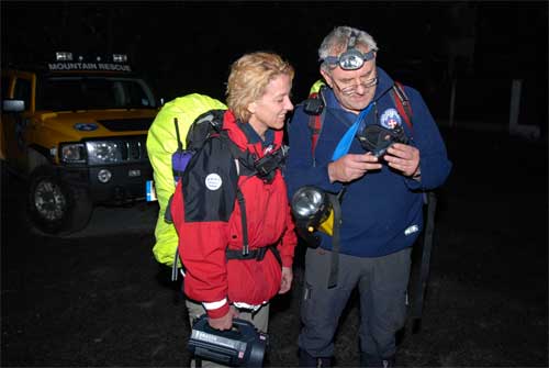
BMRT Team Members Mark Scott and Elaine Gilliland become familiar with the device on operational use during a search for a vulnerable missing person on 10th October 2008
